Click on any image to see a
larger version.
_______________________________________________________________________________________________
Selected tracking
maps from the Joint
Typhoon Warning Centre of Typhoon
Utor
tracking toward China
and Hong Kong
Warning
15
Warning
17
Warning
19
____________________________________________________________________________
July
06 2001 0130 GMT
Typhoon Utor
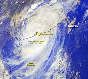
(pronounced Ooo-tar) changed course a little bit in the final hours before
landfall and made landfall about 100 kilometres north of Hong Kong at about
0800 hrs local time on July 06th.
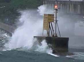
Even so, Utor bought
this city of 7 million people to a standstill and caused the cancellation
of
hundreds of international
flights causing major disruption to one of the world's biggest airline
hubs.
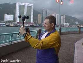
The maximum
wind speed I measured was only 62kph (35mph) and the air pressure dipped
to 979 hpa at around
0800 local time.
Utor killed at least
58 people in the northern Phillipines and is sure to cause similar
problems as it moves
into Southern China and Vietnam . (Many thanks to Howard Chan from
the Hong Kong Tourism Board for his help organizing transport etc)
Hong Kong Kong Tourism
Board Website: DiscoverHongKong.com
July
05 2001 2130 GMT
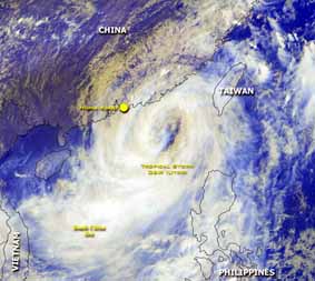
The latest satellite imagery shows the center
of Typhoon Utor will pass very close to or directly over Hong Kong
Winds up to 150kph (92mph) can be expected
soon. Typhoon warning 8 is in effect in Hong Kong
AT 5 A.M. THE CENTRE OF TYPHOON UTOR WAS ESTIMATED
TO BE ABOUT
160 KILOMETRES EAST-SOUTHEAST OF HONG KONG (NEAR 22.0 DEGREES
NORTH 115.7 DEGREES EAST) AND IS FORECAST TO MOVE NORTHWEST OR
WEST-NORTHWEST AT ABOUT 20 KILOMETRES PER HOUR TOWARDS THE COAST
OF GUANGDONG.
TYPHOON UTOR CONTINUES TO COME CLOSER TO HONG KONG. IN THE PAST
HOUR, THE GUSTS RECORDED AT CHEUNG CHAU WERE 88 KILOMETRES PER HOUR.
THE TROPICAL CYCLONE SIGNAL NUMBER 8 IS EXPECTED TO REMAIN HOISTED
IN THE EARLY MORNING.
AS THE RAIN BANDS OF UTOR ARE CONFINED TO THE SOUTH, HONG KONG WILL
BE AFFECTED BY HEAVY RAIN AND SQUALLS LATER TODAY.
July
05 2001 0400 GMT
Typhoon Utor has changed course slightly and
the eye may make landfall to the north of Hong Kong city although the system
is so big serious disruption and damage in Hong Kong is now inevitable.
According to local people and media reports this will be "the worst typhoon
for 20 years"
Typhoon alert signal 3 has now been posted
and police are erecting signs in the streets. Currently it is still fine
but overcast here.
July
05 2001 0100 GMT
According to the Typhoon Warning Center Typhoon
Utor is at this stage tracking towards a direct hit on Hong Kong at about
0800hrs local time on the 6th July. Winds expected to gust to 167kph (101mph)
Typhoon signal
level one still in effect and probably will
be raised soon. Hong Kong has an alert level scale of one to 10,
with 10 being the highest.
AT 8 A.M. LOCAL TIME, THE CENTRE OF TYPHOON UTOR WAS ESTIMATED TO
BE ABOUT
540 KILOMETRES EAST-SOUTHEAST OF HONG KONG (NEAR 20.1 DEGREES NORTH
118.8 DEGREES EAST) AND IS FORECAST TO MOVE NORTHWEST AT ABOUT 22
KILOMETRES PER HOUR TOWARDS THE COAST OF GUANGDONG.
MIN SURFACE PRESSURE 960 HPA
TYPHOON UTOR CONTINUES TO MOVE CLOSER TO HONG KONG. LOCAL WINDS
ARE STRENGTHENING GRADUALLY. THE CHANCE OF HOISTING THE STRONG WIND
SIGNAL NO. 3 IN THE MORNING IS HIGH.
July
04 2001 1550 GMT
Typhoon Utor is at this stage tracking towards
Hong Kong and China with winds gusting to 195kph (120mph)
I am in Kowloon, Hong Kong now awaiting the
arrival of Typhoon Utor.
Typhoon signal level one has been declared
in Hong Kong.
July
03 2001 2240 GMT
Typhoon Utor has altered course and speed
up.....I am now no longer going to Taiwan but going to
Hong Hong now.
July
03 2001 0930 GMT
Typhoon Utor intensifies west of the Phillipines
and tracks towards Taiwan and China. This typhoon will
pass close to or hit Taiwan on the 5th
July with destructive winds gusting to 240 kph (150 mph)
I will be intercepting this event in southern
Taiwan and live updates and photographs will be posted on
this site where possible.
Geoff Mackley 06 July
2001.
Back
to Geoff's weather links
Back
to stock footage list
