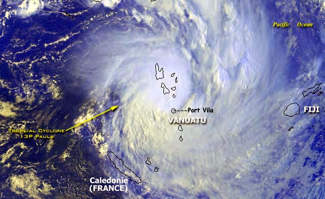
Satellite image courtesy of: NOAA
Graphics courtesy of: JOINT TYPHOON WARNING CENTER
Corresponding satellite images for the above warnings
WARNING 4
The above two graphics show the slight change of course of
Cyclone Paula's track in the hours preceeding landfall on Efate Island
that spared Port Vila a direct hit.
__________________________________________________________________________________________
These are the original updates
as posted during Cyclone Paula:
------------------------------
28 Feb 0525z (+11hrs for Vanuatu
local time)
I have arrived at Port Vila after one of the most hair raising landings
I have experienced.
Our first attempt at landing was aborted metres from touchdown and
we spent the next 30 minutes circling in turbulance waiting for a clear
shot at actually seeing the land at all. The sea below us was a wild mass
of churning water and huge waves.PHOTO
FROM PLANE WINDOW
We successfully landed on our second attempt to the loud cheering
of every one on the plane.
We had to run in from the runway and everyone was drenched in seconds
by torrential horizontal rain.PHOTO
AT VILA AIRPORT Port Vila is almost completely boarded
up and Paula is intensifying. There will be power and communication outages
so this will probably be the only report from Cyclone Paula.
If the JTWC prediction is right Port Vila will get an almost direct
hit with very destructive winds gusting to 220kph in 6 hours from now (this
will be about midnight,local time) I repeat, if this occurs there may be
no communications from here at all for days, Geoff .....
28 Feb 1300z (+11hrs for Vanuatu
local time)
Cyclone Paula is currently over or near Efate Island and for several
hours now the wind speed is blowing at what I estimate to be around 150kph
with a period of stronger gusts at about 2230hrs, local time. It is 0030
now and the wind has not diminished and is blowing from the north.
Judging from the type of damage I am seeing it is consistant with
a CAT 1 cyclone damage, however, this is a strong CAT 2 storm and is still
intensifying. The cyclone centre is currently passing off the east
coast of Efate Island, on the other side of the island the wind strength
will be higher, that road is impassable. Radio reports are carrying stories
of communication difficulties on the islands of Malakula and Santo that
were hit by Paula earlier in the evening including unconfirmed reports
of missing person/s and a boat sinking. From driving around Port Vila for
the last 3 hours a lot of tree damage is evident with some roads blocked
by fallen trees, including the road to the airport. Little has been observed
in the way of building or property damage yet although it is midnight here
at present and visibility is limited, power is off in parts of Port Vila..
flooding is also starting to affect some areas.
01 March 0830z (+11hrs for Vanuatu
local time)
A tour of port Vila this morning reveals little damage to buildings
in Port Vila although I saw 5 boats that had run aground or sunk in Port
Vila harbour. The local weather station in Vila recorded a sustained
wind speed of 85 knots, (160kph) at the height of TC Paula.
A ship anchored in the harbour recorded a pressure of 984hpa on
their barometer between 2200 and 2300hrs, local time
PHOTO OF BAROMETER
GRAPH.
PHOTO OF SINKING YACHT.
The eye of Cyclone Paula appears to have passed 30 to 50 kilometres
to the east of Port Vila during the night sparing the town the more
destructive winds that would have been closer to the eye wall. However,
according to Prescilla Molisa , from the Vanuatu Disaster Management
Comittee, who I met on a tour of the worst affected areas, says that in
rural areas where the housing is poor there has been considerable damage
to basic housing,
PHOTO OF DESTROYED
HOUSE
and although these can usually be rebuilt relitavely quickly it
is the extensive damage to root crops , paw paws etc that will probably
cause serious food shortages in the coming weeks and may also prompt calls
for aid from Australia and New Zealand.
PHOTO OF DESTROYED
CROPS
Little is known yet about the damage done by the cyclone on other
islands especially those in the Shepherd group that would have taken a
direct hit from Cyclone Paula. Cyclone Paula is still intensifying and
moving south - east as shown by the latest chart from the JTWC.
No other significant Pacific islands appear to be in it's path at
the moment.
______________________________________________________________________________________
Back to Geoff's weather
links
Back to stock footage
library
Back to site Directory