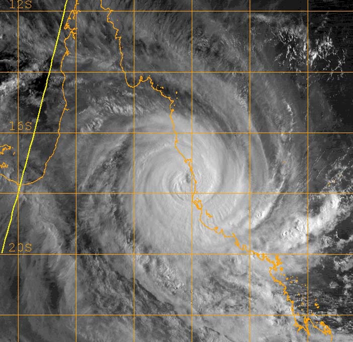

Cat 5 Cyclone Larry
making landfall at Innisfail, Queensland - Australia at 2234z on 19 March 2006.
Satellite image from
NRL Monterey Marine
Meteorology Division
Click on any image above to see the full sized image
Selected
tracking maps and satellite images of Cyclone Larry
Intercepting Cyclone Larry proved very difficult right from the start, arriving in Sydney the day before the storm was due to make landfall to be told the flight to Cairns was cancelled "due to the cyclone" this was clearly untrue as up to date satellite images showed the cyclone to be well away from Cairns at that stage (residents of Cairns later told me it was still fine and calm there at midnight, many hours after my flight should have arrived) So, instead of arriving a mere 100km from Innisfail I now found myself, (and TV3 reporter Amanda Gillies, who was travelling with me to cover the cyclone for TV3 News, New Zealand ) about 2500km away from Innisfail, !$!Y@#*!!!!!! Some quick work at the ticket counter and we were on a flight to Brisbane and then on another flight up to Rockhampton, but this still left us with nearly 1000km to go before morning, we loaded up a rental 4WD with food, water and cans of fuel for the epic non stop drive. I knew full well that we were going to end up actually driving straight into the cyclone as we went north, when it comes to a CAT 5 this is not recommended but we had no choice, as we neared Cardwell we drove straight into Larry, meeting a CH7 tv crew who told me their bosses had ordered them not to go any further, we heard from them and the police that we had no chance of going any further north due to flooding and falling trees and power lines, however, we had come this far and chose to at least try, driving north into 150k winds, falling trees and flooding we soon found our path blocked by falling trees, time after time we tried to bypass the blockages, could we drive along a farm track, a drainage ditch or even the railway line ?, we drove around in circles with flooded roads, fallen trees and power lines at every turn, the best efforts of locals to give us directions had us continuing to go around in circles, eventually we found a road that showed promise, until we got to a bridge with the river flowing over the top of it, the railings were still visible and the water wasnt flowing too fast so, after donning a lifejacket and wading through to check the state of the bridge, Amanda followed in the 4WD. We arrived in Tully in the middle of the cyclone but from listening to local radio we knew that mayhem was going on in Innisfail, just a few K's up the road, we continued on a bit further to find a series of very large trees blocking the highway, there was no way around or through this, racing back to Tully I tried to hire a bulldozer but none was to be found. So ended our marathon efforts to intercept the centre of Cyclone Larry, there was still considerable damage at Tully and nearby Mission Beach, which we filmed and sent out by satellite to New Zealand. The next day we got through to Innisfail to a scene of destruction and spent the next 2 days there documenting the situation. Virtually all the suger cane and banana crops had been wiped out. The generosity of locals was pretty amazing, their town had been wrecked but they still went out of their way to help us, one man even connected a generator up to his broken petrol station pumps to give us fuel and then gave us food and drink as well.
Geoff Mackley 24 March 2006.