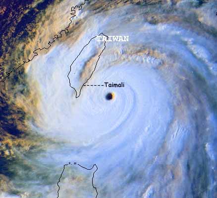
Supertyphoon Bilis
approaching landfall on Southern Taiwan
22 August 2000.
Satellite image from NOAA
_______________________________________________________________________________________________
View
a larger satellite picture of Supertyphoon Bilis
_______________________________________________________________________________________________
Selected tracking
maps from the Joint
Typhoon Warning Centre of Supertyphoon
Bilis
tracking toward Taiwan
Warning
09
Warning
10
Warning
11
Warning
12
Warning
13
Warning
14
Warning
17
Warning
18
Warning
19
_____________________________________________________________________________________________
Transcript
of a CNN report on Supertyphoon Bilis
CNN
graphic of Bilis's track
The eye of Supertyphoon Bilis (pronounced Bee-lees) crossed the coast of Taiwan at about two in the morning on the 23rd of August 2000 near the industrial town of Taitung. Trying to film a category 5 storm in the middle of the night is almost impossible and I spent the night in a 3 story solidly constructed hotel which at the height of the typhoon shuddered with the the wind gusts that in places reached 250 kilometres per hour. In the morning most of the damage was north of the town of Taimali, where I spent the night, and the most severe flooding seemed to be on the other side of the island which is very mountainous. Getting to the right place at the right time for this typhoon proved more more of a drama than the typhoon itself. Rushing to Taiwan from New Zealand I arrive in Kaohsiung on the last flight before they were all cancelled in the midst of a violent thunderstorm and thinking about all those stories of aircraft mishaps during typhoons. Although I could not understand a word of taiwanese or read chinese characters I still had to find my way out of this huge city somehow, and quickly. The rental car lady was very helpful and spoke some english, I told her I was a tourist and asked her where she thought was a good place to go, she promptly showed me a beautiful place in the very area that the typhoon was going to hit, great, so if I bought back a car that looked like it had been through a shredder then I could explain the mess a little easier. The next prooblem was getting out of the city, so I found an english speaking taxi driver and paid him to drive to the main motorway out of town with me following.
Flooded roads made things difficult and at one point driving along a railway embankment and across a rail bridge to get around flooding didn't amuse the authorities, although after I had done it I notice the police, army and fire service all start to use the same short cut to bypass the flood.
Getting to the final point of landfall was a combination of phone calls from my father in New Zealand and SMS messages on a mobile phone containing the grid references of the storm's progress coming from Mark Twiname, a friend of mine, also back in New Zealand. Once on the east coast it was hard to believe the size of the storm surge. Storm surges dont get any bigger than they do before landfall of a CAT 5 event and the waves were about the size of three story buildings and looked more like tidal waves, surging up the beach and into a forest at high speed, it was a spectacular sight.
When the typhoon was over it had done more than $34 million in damage, killed 11 people and disrupted an entire country. Then it moved into China where flooding and damage continued. The Northwest Pacific area produces around 20 typhoons per year, more than any other place on earth.
Geoff Mackley 31 August 2000.
Back to Geoff's weather links
Back to stock footage list